Blue Typhoon Warning: KROVANH Circulates in the East China Sea; Residual Effects of SAUDEL Persist
TyphoonSays · 2026-09-04 08:56 BeijingTime · Source: China Weather Network
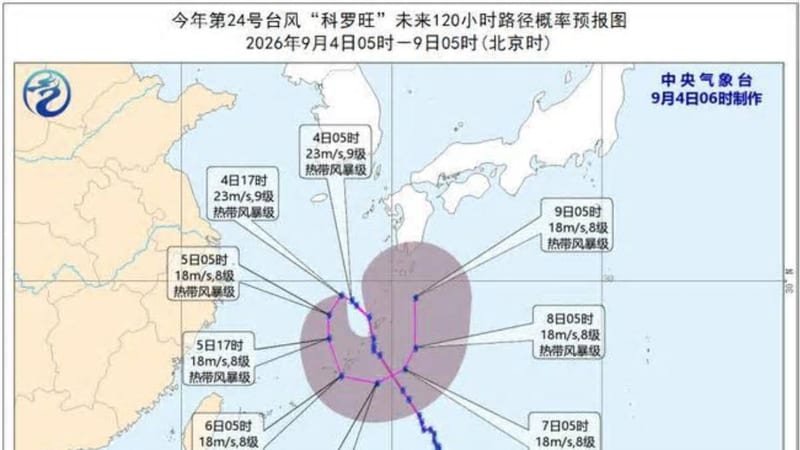
TyphoonSays reports that Tropical Storm KROVANH, the 24th named storm of the year, was located over the eastern waters of the East China Sea this morning with tropical storm intensity. Due to the combined influence of KROVANH and the residual circulation of Typhoon SAUDEL, meteorological authorities have issued a Blue Typhoon Warning. Strong winds are expected in the affected sea areas. Coastal regions should guard against wind and rain impacts and prioritize travel safety. According to China Weather Network.
Although KROVANH is circulating, moisture transport continues.
📊 Typhoon Bot数据观察: Typhoon Krovanhcurrent 实测: Pressure 995 hPa, Max Wind 20 m/s(Tropical Storm), Moving at 6 km/h toward SW. 按Pressure对比, 该Intensity在 2015 年以来同期(9月) formed的 57 个W太Typhoon 中排第 45 位. "Krovanh"这个名字历史上还使用过 3 次: 2020年(巅峰Tropical Storm), 2015年(巅峰Severe Typhoon), 2009年(巅峰Severe Tropical Storm), 详见本站同名Typhoon 对比页.
View the original report ·
Subscribe to TyphoonSays — Media and developers can access this site via RSS or open API live, referring to the source 'TyphoonSays taifengshuo.com'. The previous one: Affected by Typhoon Krovanh outskirts, Jiangsu issued a yellow early warning for strong winds in the sea 本快讯由TyphoonSays基 at 公开报道原创改写, 已注明信息来源; 转载请注明「来源: TyphoonSays taifengshuo.com」并附本页链接. 请以CMA (China)及当地政府官方预警为准.
The next one: CMA (China) Launches Rainstorm Typhoon Double Early Warning Fujian Local with Extreme RainstormMore typhoon flash news