Typhoon SAUDEL has been decommissioned; KROVANH may merge with 97W and make landfall in Japan
TyphoonSays · 2026-09-04 01:36 BeijingTime · Source: Tencent
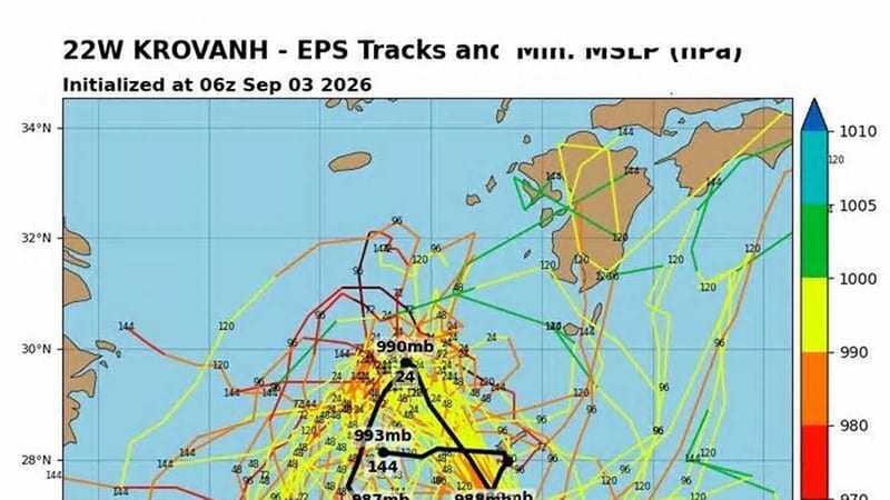
According to TyphoonSays, the China Meteorological Administration (CMA) stopped tracking Typhoon "SAUDEL" late on September 3, bringing an end to the rainfall along the southeastern coast. Currently, Tropical Storm "KROVANH" has intensified to Force 9. It is expected to linger in the East China Sea and may merge with the northward-moving disturbance 97W, eventually moving toward Japan. EU AI forecasts indicate that a new typhoon may form in mid-September, so continued monitoring of its potential path is necessary. Source: Tencent News
Is Krovanh planning a visit to Japan? Don't let your guard down; autumn typhoons are tricky, so keep a close eye on the forecasts!
📊 Typhoon Bot数据观察: Typhoon Krovanhcurrent 实测: Pressure 990 hPa, Max Wind 23 m/s(Tropical Storm), Moving at 15 km/h toward NW. 按Pressure对比, 该Intensity在 2015 年以来同期(9月) formed的 57 个W太Typhoon 中排第 43 位. "Krovanh"这个名字历史上还使用过 3 次: 2020年(巅峰Tropical Storm), 2015年(巅峰Severe Typhoon), 2009年(巅峰Severe Tropical Storm), 详见本站同名Typhoon 对比页.
View the original report ·
Subscribe to TyphoonSays — Media and developers can access this site via RSS or open API live, referring to the source 'TyphoonSays taifengshuo.com'. The previous one: HKO cancels all tropical cyclone warning signals 本快讯由TyphoonSays基 at 公开报道原创改写, 已注明信息来源; 转载请注明「来源: TyphoonSays taifengshuo.com」并附本页链接. 请以CMA (China)及当地政府官方预警为准.
The next one: Affected by Typhoon Krovanh outskirts, Jiangsu issued a yellow early warning for strong winds in the seaMore typhoon flash news